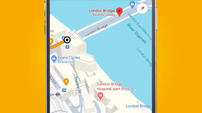
If you regularly use Google Maps on your Android or iOS phone while driving, you’ll soon find it much more helpful in big cities – thanks to the arrival of new graphics for 3D buildings.
3D buildings have been available in the Google Maps app for a while in the layers tab (just tap the Layers icon, then 3D). But they haven’t appeared while you’re in navigation mode and traveling between two points – until now.
As spotted by 9to5Google and its readers, the Google Maps app for Android and iOS has started showing 3D buildings during navigation for some users – including us. That’s a big boon for finding your way around cities, as it gives you another visual marker to help you spot your next turn.
(Image credit: Future)
To see buildings in 3D, you need to have the ‘3D’ layer turned on in the app’s ‘Map details’ section. To do this, tap the Layers icon (see above), then ‘3D’. Once you’ve entered navigation mode by typing in an address and tapping ‘directions’, you should start to see the buildings appear when you’re zoomed in.
Understandably, the feature only seems to appear when you’re in cities or highly built-up areas, and you’ll need to be zoomed into the map before they appear. But it certainly looks like a handy upgrade if you’re driving through an unfamiliar capital – and it’s also available for some on Android Auto and CarPlay, too.
Coming to Android Auto and CarPlay?
(Image credit: Future)
While we haven’t seen 3D buildings appear on Android Auto or CarPlay yet, there is anecdotal evidence that the feature has rolled out for some on both platforms in a few regions.
Some Reddit users have reported seeing the Google Maps feature appear in both Hong Kong (on Android Auto) and Canada (on CarPlay). But so far Google hasn’t made an announcement about a global rollout. We’ve asked Google about this and will update this story when we hear back.
While not a drastic overhaul for Google Maps navigation, the inclusion of 3D buildings certainly looks useful for city driving. The building outlines are roughly to scale but are also transparent (as you can see above), which means that high-rises like The Shard in London won’t block your navigation too much.
Once the feature does get a wider rollout, it’ll also certainly be one to add to our list of the many things you didn’t know Google Maps could do.
You might also like
Google Maps now looks more like Apple Maps – and a lot of people aren’t happyGoogle Maps’ fun new update makes it easier to save your favorite placesGoogle Maps could soon be getting its own AI chatbot
Source: TechRadar – All the latest technology news
Leave a Reply